Argo’s global
work beneath
the waves

Argo links ocean instruments, ships and data centers across borders. Its value depends on a complete observing network, not a fleet count alone.
The program’s current implementation overview describes an array of close to 4,000 active floats, but also says some ocean regions have too many instruments while others still have gaps. That distinction matters more than a celebratory total. A float in a well-sampled current does not automatically replace one missing from a remote basin. The network’s third millionth profile was collected in July 2024, following the first million in November 2012 and the second in November 2018. The accumulation is impressive; keeping its geography useful is a continuing operational task.

The international bargain inside the instrument
Argo is not simply a brand attached to any robot that measures seawater. Its program guidance links participation to coordinated deployment, registration, transparent metadata, common sampling practices and unrestricted sharing of observations. OceanOPS registration includes deployment plans and the variables an instrument will measure. National and regional projects operate within that shared system rather than contributing unrelated files after the voyage is over.
That framework also connects scientific work to the rights of coastal states. The program explains that authorization and notification arrangements depend on the location and type of deployment, and that non-Argo profiling floats do not automatically inherit Argo’s arrangements. The practical consequence is a division of labor: an engineering team can build a successful instrument, but the research organization must still establish where it can operate and how its observations will be shared. Argo membership is therefore an operational commitment and a technical label.
Our guide to the High Seas Treaty’s implementation examines a separate ocean-governance system. Argo’s deployment arrangements should not be confused with a treaty-created marine protected area or a biodiversity permit.

The voyage below the surface
A standard float follows a roughly ten-day mission. It spends much of that interval drifting near 1,000 meters, about 3,280 feet, then descends to around 2,000 meters before collecting a vertical profile as it rises. It measures conductivity, temperature and pressure; salinity is calculated using those measurements. At the surface it obtains a position and sends information through a satellite system.
Movement does not require a propeller following a prescribed horizontal route. A hydraulic system moves oil between an internal reservoir and an external bladder. Expanding the bladder increases the instrument’s volume without increasing its mass, reducing its average density so it rises. Reversing that change makes it sink. Batteries power the pump, sensors, controller and communications, linking the number and demands of future cycles to a finite energy supply.

A laboratory decision travels with every profile
The preparation photographs show separate pump assemblies, instrument heads and sensors before they become a working float. Their different jobs must fit together. A buoyancy system that cycles reliably is not enough if the sensor record is unsuitable for the scientific question; an accurate sensor is not useful if the instrument stops communicating after a handful of dives.
Argo’s technical community of practice focuses on testing before deployment to reduce early failures and degraded performance. Its deployment guidance also stresses clear instructions for ships of opportunity, including the recording of deployment position and time. These details can sound administrative until a measurement must be traced back to its instrument and release conditions. A missing time or an uncertain location creates work for everyone who later tries to combine that profile with others.
Basin-scale coordination groups exchange future vessel schedules and contacts to reach undersampled areas. That makes a ship’s itinerary part of the observing system’s design. The important planning question is not only whether a ship has space for another instrument; it is whether the ship can put the right instrument into a place where the network needs observations, with trained handling and the correct deployment information.

Why a cardboard box belongs in an ocean-observing story
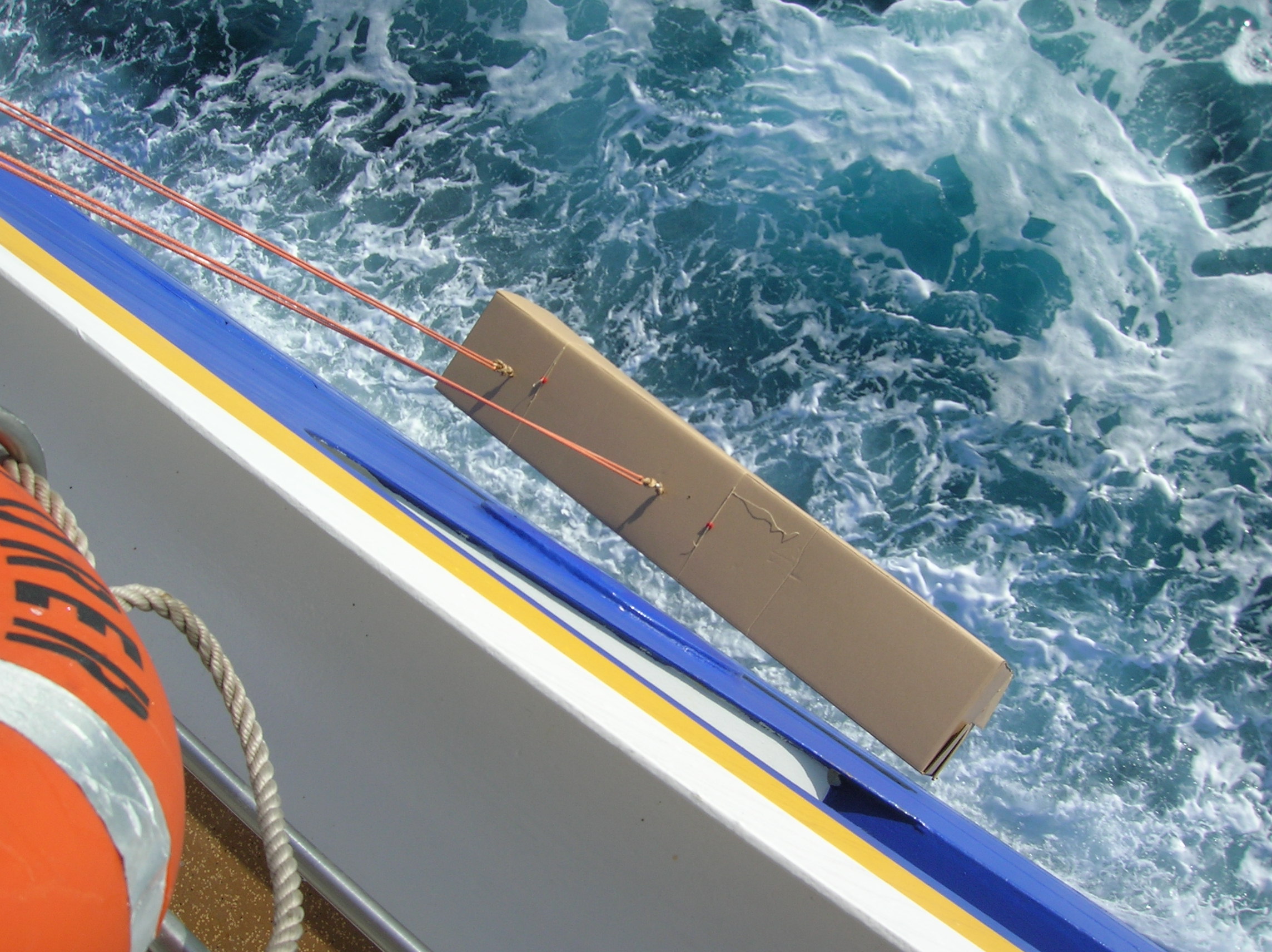
A gallery sequence from the Argo Program shows a float protected inside a long cardboard box as it is lowered from a moving ship. The box is not packaging accidentally left around an operational instrument. It is a deployment device intended to protect the float from the impact of entering the water, including braces that shield the antenna.
The same sequence shows twine secured through dissolvable candy-ring links. After release, the links dissolve so the box can open and free the float. One photograph is explicitly identified as an operation from MV Explorer while steaming at 20 knots. It illustrates one documented deployment technique, not a speed instruction for every ship or float. Operators still need the appropriate handling procedure for the instrument and the vessel.


A short surface visit with a large information load
Satellite communication is another part of the design that can be mistaken for a minor accessory. Argo’s telecommunications overview describes how newer systems allow a more detailed profile to be transmitted in less time at the surface. Many floats use GPS for location and Iridium for communication, including the ability to receive changed mission instructions.
The historical contrast is with floats using the Argos system, which need a longer surface interval to transmit their observations and establish a position. The exact interval depends on the system and circumstances; the program describes hours rather than the much shorter surface visits possible with newer communications. Less time at the surface reduces exposure to some hazards and helps extend operations into marginal seas.
One record, two timetables
A surfaced float does not send a finished climate assessment directly to a reader. Its transmission goes to a national data center for agreed real-time quality checks. Data then reach the two Global Data Assembly Centers, in Brest, France, and Monterey, California, whose holdings are synchronized. The program describes a target of approximately 12 to 24 hours from transmission to real-time availability.
A second process examines the observations more carefully over time. After deployment, routine physical recalibration of a drifting float is generally unavailable. Researchers instead compare records with suitable reference information and other observations. A longer record helps distinguish a sudden calibration shift from slow sensor drift or a genuine change in water properties.
These two timetables serve different needs. A forecast cannot wait indefinitely for a carefully assessed multiyear record; a study of subtle long-term change cannot treat quick delivery as proof that every bias has been resolved. Delayed-mode quality control is not evidence that the original transmission failed. It is a separate level of scrutiny designed for uses where small systematic differences matter.

What a forecast gets from water below the weather map
Argo observations contribute to the initial conditions used by ocean forecasting centers. Data assimilation combines observations with an earlier model forecast to estimate the present ocean state, after which a numerical model advances that state forward. Satellite sea-surface temperature and altimetry provide complementary information; a vertical profile supplies measurements beneath the visible surface.
This distinction helps explain why a global ocean forecast is not a picture assembled by connecting the latest float dots. The observations are uneven in space and time, and the model must represent movement and physical relationships between measurements. Forecasting skill depends on the observations, their quality, the assimilation method and the model itself. An individual float does not issue a hurricane warning or predict next season’s weather.
For seasonal prediction, the relevant initial state extends beyond the ocean to the atmosphere, land and ice, and multiple forecasts are used to represent uncertainty. Argo’s contribution is a better-informed starting point for that system. Calling the floats useful for prediction is justified; promising a particular local outcome from one profile would confuse an input with a forecast product.
Heat, salt and the importance of returning in another season
The ocean stores most of the additional heat accumulated in the climate system, so measurements below the surface are essential to understanding changes that cannot be read from air temperature alone. Argo’s climate overview explains why observations must cover both geography and time: heat moves within and between basins, while seasonal cycles can obscure the longer-term change a researcher is trying to identify.
Historically, ship observations were concentrated along traveled routes and in seasons when vessels could operate. Autonomous profiles reduce some of those sampling imbalances. They do not make every location continuously observed, but they provide repeated measurements outside the convenient windows of a research cruise.
Salinity adds another dimension. Evaporation and precipitation influence how salty surface waters become, while ocean circulation redistributes those waters. Temperature and salinity profiles together describe more of the water column than a surface-temperature map alone. For the reader comparing climate graphics, the depth range, time interval and treatment of seasonal variation are not fine print. They determine what change a figure can actually show.
Deep Argo asks a different engineering question
Core Argo’s approximately 2,000-meter reach does not cover the full depth of the ocean. Deep Argo extends the measurement problem into water below that range. The program lists models designed for 4,000 meters and others capable of 6,000 meters, almost 19,700 feet. The extra depth demands more than telling an ordinary float to keep descending.
A photograph of a Deep SOLO glass sphere shows the pressure housing as a prominent part of the instrument. Another shows the SBE-61 conductivity-temperature-depth sensor mounted on the float. These are examples of the equipment needed to make full-depth sampling practical; the photograph alone cannot certify any particular instrument’s accuracy.
The Deep Argo mission page describes regional arrays as steps toward a standing global array, rather than a completed uniform deep-ocean network. It also distinguishes aspirational sensor-performance goals from performance already achieved. That distinction should survive into public reporting. A capability demonstrated by a model, a regional deployment and a sustained global observing system are three different accomplishments, each requiring evidence of its own.


Adding oxygen and chemistry without losing the common network
Biogeochemical Argo adds sensors for variables such as oxygen, nitrate, pH, chlorophyll, suspended particles and downwelling light. These observations extend the questions the array can address—from the physical state of the water to biological productivity, nutrient supply, carbon uptake and oxygen conditions below the surface.
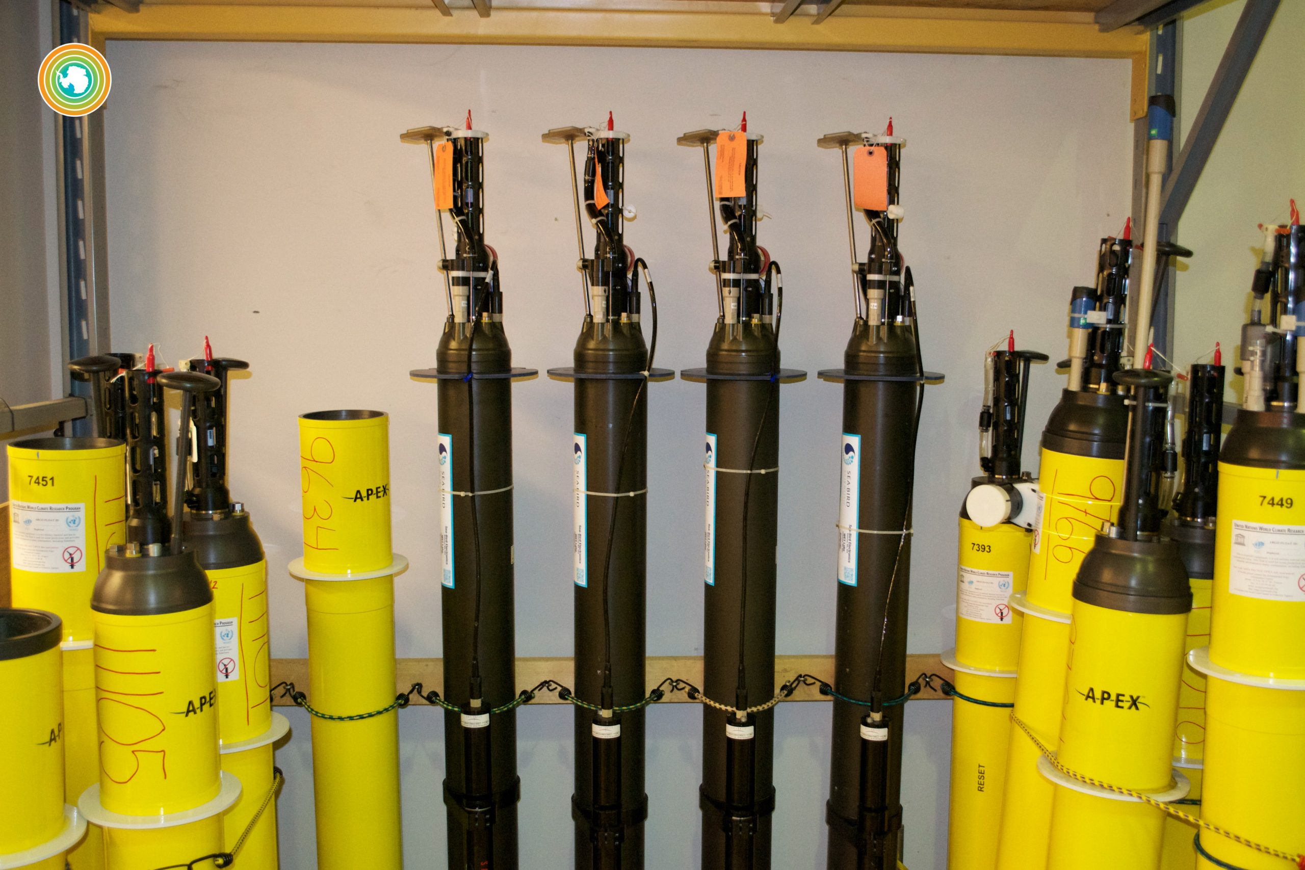
The laboratory photograph of yellow APEX and dark NAVIS units makes the hardware variation visible. But additional sensors also bring calibration, reliability, software and data-management demands. The BGC mission’s guidance emphasizes those challenges and describes national programs validating performance alongside shipboard observations and other observing systems.
Ocean-color satellites offer a powerful surface view, yet cloud cover and depth limit what that view can reveal. Profiling instruments help extend observations into the water column and through seasons when a clear satellite image may be unavailable. That is complementary evidence, not a reason to discard satellites or research ships. The larger aim is to combine observations whose strengths and blind spots differ, while keeping the temperature, salinity and pressure stream useful across the wider Argo program.

Ice changes the meaning of a missing transmission
In polar seas, reaching the surface can damage an instrument against ice. Ice also prevents the satellite communication needed to transmit measurements and establish a position. Polar Argo therefore involves adaptations such as more resistant hardware, strategies that avoid an unsafe ascent, storage of profiles that cannot be sent immediately, and methods to estimate positions beneath the ice.
A stored observation and an immediately transmitted observation are not operationally identical. A profile may exist before a researcher on land receives it; an estimated under-ice position does not have the same basis as a surface GPS fix. The program’s polar guidance explicitly explains that some mapped under-ice positions use interpolation.
The benefit is access to seasons that research vessels have historically sampled less often, especially harsh polar winters. The limitation is that autonomous operation must accommodate the ice rather than assume an open surface. Polar floats are also only one part of the necessary observing equipment; the program notes that ice-tethered profilers can be more suitable in persistent multi-year ice. One platform does not fit every ocean environment.
The cost of a persistent presence
A float is a physical object with batteries and materials, not a weightless stream of data. Argo’s environmental assessment discusses what happens when instruments exhaust their energy and eventually sink and corrode. It also weighs recovery against the cost and emissions of sending ships across large distances to retrieve scattered instruments.
The program’s conclusion favors the small marginal impact of deployments made from ships already operating in an area, while supporting recovery where practical and useful. That is an assessment of trade-offs, not a claim that instruments leave no material behind. Laboratory and engineering recovery can have value even when recovering every float would be impractical.
The comparison also needs a realistic alternative. Replacing the same broad coverage with repeated dedicated ship surveys would require substantial ship time, while other expendable instruments create their own material footprint. A responsible account should make those alternatives visible rather than presenting either unattended instruments or research vessels as impact-free. The observing system exists because there is no effortless way to measure a vast, deep, moving ocean.

From an ambitious design to a sustained public record
OneArgo brings together wider geographic coverage, greater sampling in important regions, deeper profiles and biogeochemical measurements. Its design page describes a transition that must accommodate technical hurdles, supplier capacity, data-management readiness and national and international partnerships. A target array is not the same thing as a funded, deployed and maintained array.
That is the lesson connecting the ship photographs to the data centers. The crane, the buoyancy pump, the calibration check, the satellite link and the quality-control record are successive parts of the same public service. Improvements at one point need support elsewhere: additional measurements need transmission capacity and expertise; more instruments need deployment opportunities; a global design needs countries willing to sustain contributions beyond a single cruise.





Comments
Post a Comment